Below is the final tally from the NWS; I had a link to it previously but it is no longer there. It is a long list of snowfall and windspeed readings for multiple towns throughout New England. It also provides a brief comparison of Blizzard Charles with Blizzard Larry (the blizzard of 78).
Essentially we are talking large differences between 78 and 05. We should soon see more evidence within the storms following period of recovery. A couple of days for 2005 vs a week or more for 1978.
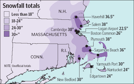
The following are unofficial observations taken during the past 22 hours for the storm that has been affecting our region. appreciation is extended to highway departments, cooperative observers, skywarn spotters and media for these reports. This summary is also available on our home page at weather.Gov/Boston
********************Storm total snowfall********************
Location storm total time/date comments
snowfall of
(inches) measurement
Connecticut
Hartford County
Southington 12.8 854 PM 1/24 General public
Windsor Locks 12.5 108 PM 1/23 airport ang (bdl)
Burlington 1 2.0 851 AM 1/24
West Hartford 12.0 647 AM 1/24 St
South Windsor 11.5 114 PM 1/23
Windsor 11.0 820 PM 1/23 St
Unionville 8.8 130 PM 1/23
Tolland County
Stafford Springs 16.0 223 PM 1/23 St
Hebron 12.0 120 PM 1/23
Andover 7.0 309 PM 1/23
Storrs 7.0 123 PM 1/23
Windham County
North Grosvenordale 14.0 218 PM 1/23
Hampton 11.1 700 AM 1/24 CO-Op observer
Thompson 10.0 1136 AM 1/23
Plainfield 9.5 122 PM 1/23
ashford 9.0 116 PM 1/23
eastford 8.0 121 PM 1/23
Mansfield Hollow Dam 6.0 700 AM 1/24 CO-Op observer
Massachusetts
Barnstable County
Sagamore Beach 36.0 944 PM 1/23
harwich 35.0 1049 PM 1/23 general public
North Eastham 32.0 528 PM 1/23
Yarmouth Port 30.0 240 PM 1/23
brewster 25.5 820 PM 1/23
Sandwich 24.0 315 PM 1/23 NWS employee
Barnstable 20.0 244 PM 1/23
Bristol County
New Bedford 30.0 235 PM 1/23
North Attleboro 28.1 737 AM 1/24
Taunton 26.0 331 PM 1/23 5Ft Drifts
Fairhaven 25.5 847 PM 1/23 St
Rehoboth 25.0 247 PM 1/23
east Fairhaven 23.6 1151 AM 1/23
Norton 23.5 813 AM 1/24
Easton 23.0 107 PM 1/23 W.E. 1.71
Acushnet 21.5 304 PM 1/23
Somerset 20.0 303 PM 1/23 T
aunton 18.0 700 PM 1/23 NWS Office kbox
Seekonk 15.0 430 PM 1/23 5 Ft drifts
Dukes County
Edgartown 24.0 240 PM 1/23
Marthas Vineyard 23.0 945 AM 1/24
Essex County
Salem 38.0 256 PM 1/23 Em
Haverhill 36.5 959 PM 1/23 7 Ft drifts
North Andover 33.0 100 PM 1/23 6Ft drifts
North Beverly 32.0 825 PM 1/23 St
South Hamilton 31.0 1130 AM 1/23
Peabody 30.0 155 PM 1/23
Saugus 30.0 234 PM 1/23
Topsfield 30.0 552 PM 1/23 St
West Peabody 30.0 353 PM 1/23
Marblehead Neck 29.0 234 PM 1/23
Methuen 27.0 204 PM 1/23
Salem 27.0 1040 PM 1/23 Salem state
Manchester 26.5 309 PM 1/23
Georgetown 26.4 400 PM 1/23
Beverly 26.0 802 PM 1/23 CO-Op observer
Ipswich 26.0 310 PM 1/23
Marblehead 26.0 941 PM 1/23 St
Gloucester 25.0 1145 AM 1/23
Lynn 24.0 250 PM 1/23
Rowley 24.0 256 PM 1/23
Swampscott 24.0 353 PM 1/23
Lawrence 23.0 130 PM 1/23
Newburyport 20.0 846 AM 1/24
Franklin County
Ashfield 15.5 1130 AM 1/23
Sunderland 12.5 700 AM 1/24 CO-Op observer
Hampden County
Granville 12.0 215 PM 1/23
Montgomery 11.5 1103 AM 1/23
Wilbraham 11.0 207 PM 1/23
Southwick 10.0 223 PM 1/23 St 0.84 We
Monson 9.0 1149 AM 1/23
Hampshire County
Southampton 12.5 206 PM 1/23
Worthington 12.5 700 AM 1/24 CO-Op observer
Northampton 12.0 232 PM 1/23
South Hadley 11.0 231 PM 1/23
Westhampton 10.5 1126 AM 1/23
Amherst 10.0 206 PM 1/23
Belchertown 8.5 205 PM 1/23
Middlesex County
Melrose 36.0 116 PM 1/23
Cambridge 30.0 258 PM 1/23
Wakefield 28.0 400 PM 1/23
Billerica 27.5 917 PM 1/23
North Woburn 27.5 224 AM 1/24 St 6 Ft Drifts
Burlington 27.0 850 AM 1/24
South Chelmsford 27.0 114 PM 1/23
everett 26.5 300 PM 1/23
belmont 26.0 918 PM 1/23 St
Winchester 25.8 1104 PM 1/23
east arlington 25.0 400 PM 1/23
North Billerica 25.0 100 PM 1/23
Wilmington 25.0 137 PM 1/23 St
North Chelmsford 24.0 440 PM 1/23
Woburn 24.0 1040 PM 1/23
Natick 22.0 700 AM 1/24 CO-Op observer
Wayland 22.0 340 PM 1/23
Westford 22.0 526 PM 1/23
Maynard 21.7 812 AM 1/24
Lexington 21.0 249 PM 1/23
stoneham 21.0 123 PM 1/23
Carlisle 20.8 1113 AM 1/23
ayer 20.3 330 PM 1/23 St
Littleton 19.0 241 PM 1/23
Chelmsford 18.5 219 PM 1/23 St
Dracut 18.2 220 PM 1/23 St
dunstable 18.0 1245 PM 1/23
Pepperell 18.0 249 PM 1/23
Townsend 18.0 402 PM 1/23 St
shirley 14.0 105 PM 1/23
Hudson 13.5 300 PM 1/23
Nantucket County
Nantucket 24.0 400 PM 1/23
Norfolk County
Weymouth 28.5 244 PM 1/23
Braintree 28.3 442 PM 1/23
Milton 27.0 400 PM 1/23
South Weymouth 27.0 918 PM 1/23 St
Sharon 26.0 430 PM 1/23
Foxboro 25.1 511 PM 1/23
Millis 25.0 400 PM 1/23
Needham 25.0 921 PM 1/23
Randolph 25.0 819 PM 1/23 St
Franklin 23.0 309 PM 1/23 St
Canton 22.0 259 PM 1/23
Dedham 22.0 400 PM 1/23
Walpole 21.2 700 AM 1/24 CO-Op observer
plainville 20.0 248 PM 1/23
east Milton 19.0 856 AM 1/24 Blue Hill obs (mqe)
Wellesley 17.2 239 PM 1/23
Plymouth County
Plymouth 38.0 702 PM 1/23
Plympton 35.0 1041 PM 1/23 general public
Lakeville 30.0 117 PM 1/23
manomet 28.0 1040 PM 1/23 St
Rockland 27.0 803 PM 1/23
Wareham 26.0 309 PM 1/23
Marshfield 25.0 230 PM 1/23
hanson 24.2 311 PM 1/23
Kingston 24.0 941 PM 1/23 St
West Duxbury 24.0 243 PM 1/23
Whitman 23.0 302 PM 1/23
Scituate 21.5 401 PM 1/23
Brockton 21.2 520 PM 1/23
marion 21.0 835 PM 1/23 St
Hingham 20.5 507 PM 1/23
Hingham 20.0 857 AM 1/24 W.E. 1.45
Suffolk County
Winthrop 28.6 400 PM 1/23 St
Winthrop Square 27.0 1000 PM 1/23
Boston common 26.0 116 PM 1/23 NWS employee
roslindale 25.5 305 PM 1/23 St
east Boston 22.5 700 PM 1/23 Logan kbos
Worcester County
Northborough 26.0 319 PM 1/23
Uxbridge 26.0 129 PM 1/23
Worcester 24.1 1124 AM 1/23 airport (korh)
westminister 23.4 1000 AM 1/23
Shrewsbury 23.0 325 PM 1/23
Webster 23.0 202 PM 1/23
Gardner 22.0 250 PM 1/23
southborough 22.0 311 PM 1/23
North Grafton 21.0 104 PM 1/23 ret NWS orh oic
Fitchburg 20.7 210 PM 1/23
Phillipston 19.3 1112 AM 1/23
holden 19.0 204 PM 1/23
lunenburg 18.5 202 PM 1/23
Boylston 18.1 304 PM 1/23
Old Sturbridge 18.0 203 PM 1/23
hopedale 17.5 1200 PM 1/23
Lancaster 17.0 1131 AM 1/23 0.68 h2o
leicester 17.0 133 PM 1/23 3-4 Ft drifts
Harvard 15.0 933 AM 1/23
Oxford 15.0 207 PM 1/23
west brookfield 15.0 230 PM 1/23
Ashburnham 14.0 917 PM 1/23 St
West Warren 12.5 314 PM 1/23
Athol 12.0 233 PM 1/23
Petersham 12.0 1104 AM 1/23
New Hampshire
Cheshire County
Dublin 18.5 121 PM 1/23
alstead 12.5 103 PM 1/23
Hinsdale 11.0 940 AM 1/24
Swanzey 9.0 1210 PM 1/23
Hillsborough County
Francestown 21.0 813 AM 1/24
Hollis 19.0 345 PM 1/23
Nashua 18.5 400 PM 1/23 St
New Ipswich 17.5 135 PM 1/23
Wilton 17.5 1144 AM 1/23
greenville 16.5 220 PM 1/23
Hudson 15.6 136 PM 1/23 St
Bedford 15.0 1200 PM 1/23
Milford 15.0 1105 AM 1/23
South Weare 12.5 429 PM 1/23 St
Rhode Island
Bristol County
Bristol 21.0 502 PM 1/23 St
Kent County
West Warwick 24.5 251 PM 1/23
Warwick 23.4 102 PM 1/23 TF Green (Pvd)
Warwick 20.9 316 PM 1/23
Coventry 17.5 440 PM 1/23 St
Newport County
Little Compton 27.0 410 PM 1/23
Tiverton 21.1 325 PM 1/23
Providence County
Burrillville 23.0 1130 AM 1/23
Johnston Memorial 22.5 403 PM 1/23 NWS employee
greenville 21.5 113 PM 1/23
Cranston 21.0 253 PM 1/23
Smithfield 21.0 1210 PM 1/23
Cumberland 20.0 915 PM 1/23
Rumford 19.0 1046 PM 1/23
Woonsocket 19.0 700 AM 1/24 CO-Op observer
Woonsocket reservoir 18.9 155 PM 1/23 1.36 we
pawtucket 16.0 210 PM 1/23
north foster 14.7 812 AM 1/24
Washington County
South Kingstown 22.0 1105 AM 1/23
Hopkinton 21.0 237 PM 1/23
Westerly 20.0 534 PM 1/23 5Ft Drifts
exeter 18.0 1104 AM 1/23
North Kingstown 17.0 102 PM 1/23
*********************Maximum wind gust*********************
Location maximum gust time/date comments
speed of
(mph) measurement
Massachusetts
Barnstable County
Sandwich 83.0 1255 PM 1/23 Skywarn
Barnstable 72.0 321 AM 1/23 skywarn
Provincetown 67.0 735 AM 1/23 pvc AWOS
Hyannis 66.0 1052 AM 1/23 hya ASOS
Falmouth - east 62.0 905 AM 1/23 skywarn
Chatham 60.0 1029 AM 1/23 cqx ASOS
Bristol County
New Bedford 54.0 651 AM 1/23 Ewb ASOS
Attleboro 52.0 748 AM 1/23 skywarn
Somerset 48.0 715 AM 1/23 skywarn
Taunton 48.0 623 AM 1/23 tan ASOS
Fairhaven 46.0 121 AM 1/23 skywarn
Dukes County
Marthas Vineyard 59.0* 1157 AM 1/23 Mvy ASOS
West Tisbury 48.0 1251 AM 1/23 skywarn
Essex County
Salem 62.0 516 AM 1/23 Salem State
Lawrence 57.0 400 AM 1/23 skywarn
Nantucket County
Nantucket-Madaket 84.0 930 AM 1/23 radio station
Nantucket 75.0 905 AM 1/23 skywarn
Nantucket 74.0 904 AM 1/23 ack ASOS
Norfolk County
East Milton 59.0 145 AM 1/23 mqe ASOS
Blue Hill Foxboro 53.0 635 AM 1/23 gillette stadium
Plymouth County
Plymouth 72.0 905 AM 1/23 Skywarn
manomet 71.0 1020 AM 1/23 spotter
Scituate 68.0 715 AM 1/23 spotter
Plymouth 62.0 651 AM 1/23 pym ASOS
Brockton 50.0 832 AM 1/23 skywarn
Suffolk County
Boston 55.0 150 AM 1/23 Bos ASOS Logan arpt
Worcester County
Worcester 47.0 952 AM 1/23 Orh ASOS
Rhode Island
Kent County
Warwick 60.0 722 AM 1/23 Pvd ASOS TF Green arpt
Newport County
Newport 53.0 926 AM 1/23 Uuu ASOS
Providence County
Providence 52.0 715 AM 1/23 Skywarn
Washington County
Block Island 54.0 1247 AM 1/23 Skywarn
Westerly 52.0 747 AM 1/23 skywarn
Westerly 49.0 723 AM 1/23 wst ASOS
Block Island 48.0 435 AM 1/23 bid AWOS
*Last of several occurrences
Kab/ws/evt/drag/tlm